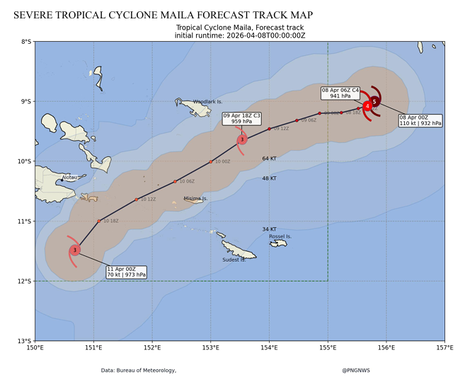
The category 5 Tropical Cyclone (TC) Maila is expected to return to PNG territory in the early hours of Thursday morning and move towards southwest over the next couple of days.
According to the Papua New Guinea (PNG) National Weather Service (NWS) TC Maila is currently in the Solomon Islands territory.
Mr. Lusete Laso Mana, the Acting Director, stated that when TC Maila returns, it will be at slow transit speed along its path towards southwest, which will cause catastrophic wind gusts and unprecedented rainfall accumulation and structural fatigue.
“This will lead to flash flooding, king tides, landslides, and coastal inundation, while houses, power poles/lines and trees to be blown off and potential communications breakdown to be expected in the outer islands of Milne Bay Province.”
Now, the areas under alert include Rossel Island, Sudest Island, Misima Island, Woodlark Island and Kiriwina Island in Milne Bay Province and South Bougainville in the Autonomous Region of Bougainville. The areas on watch for gusty winds and rainfall include provinces in Southern Region, Momase Region and New Guinea Islands Region.
“As such, the National Disaster Centre, with technical advice from the National Weather Service, urgently urges the Milne Bay Provincial Administration to inform people in the above-mentioned islands to move to inland high-grounds and safe places.”
“Furthermore, restriction must be made for small crafts or vessels to go out during this time and prepare any emergency kits or life-saving supplies on board when travelling out to sea,” Mr. Mana added.
For provinces under watch, take all necessary precautionary measures to minimize potential risks from TC Maila, the National Disaster Centre is issuing this warning to all maritime provinces and calls for immediate preventive action.
The Centre will continue to work closely with relevant technical agencies to monitor the situation and provide further updates.